Switzerland
 |
|
Contact person for provided information:
Daniel Steudler
Swiss Federal Directorate for Cadastral Surveying
Seftigenstrasse 264, CH-3084 Wabern, SWITZERLAND
www.cadastre.ch / www.swisstopo.ch
Part 1: Country Report
A. Country Context
A.1 Geographical Context
Switzerland is situated in the centre of Western Europe, bordering with Germany, Austria, Liechtenstein, Italy and France. Its territory covers an area of 41,290 sq km and is dominated by mountain ranges (Alps in the South, Jura in the Northwest) with a central plateau of plains, rolling hills and large lakes. The highest point is Dufourspitze with 4,634m, while the lowest point is Lago Maggiore at 193m above sea level.
The total population is 8,420,000 (end of 2017). The largest urban areas are Zurich (950,000), Geneva (460,000), Basle (410,000), Berne (320,000), and Lausanne (290,000). Switzerland is relatively densly populated, with most of the population concentrated in the central plateau between Jura and Alps. There are four languages in Switzerland that are used and recognized as official administrative languages. About 65% of the population speak German, 19% French, 8% Italian, and 1% Romansch; a remaining 7% speak other languages.
--> Map of Switzerland with cantonal, municipal, and cadastral boundaries
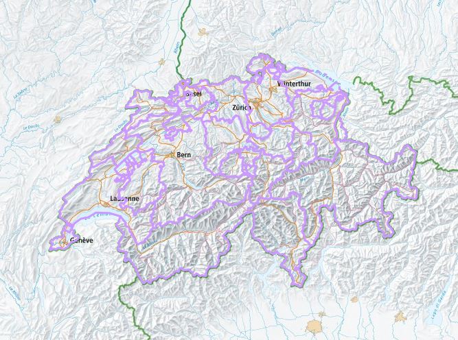
Figure 1: Topography of Switzerland and the 26 Cantons
A.2 Historical Context
After the last civil war of 1847, the loose confederation of states (cantons) was replaced by a soundly structured federal state, in which, however, the autonomy of the cantons and municipaltiies was largely maintained. Many parts of the present Swiss Federal Constitution still correspond to the first modern version of 1848. Subsequent Swiss history led not to a unitary state, but to a nation by will in which small municipalities of varying size, economic strength and cultural traditions (language, religion etc.) live alongside in mutual respect.
Switzerland's independence and neutrality have long been respected by the major European powers and it was not involved in either of the two World Wars. The political and economic integration of Europe over the past few decades, as well as Switzerland's role in many UN and international organizations has strengthened Switzerland's international role. Switzerland is active in many UN and international organizations, but retains a strong commitment to neutrality. This neutrality has long prevented Switzerland from becoming member in the UN itself, which it finally joined in 2002.
Although there is a very close cooperation with the European Union (EU), Switzerland is not a member. In recent years, it has brought its economic practices largely into conformity with the EU to enhance its international competitiveness. Although Switzerland is not pursuing full EU membership in the near future, agreements have been signed in 1999 to further liberalize trade ties.
A.3 Current Political and Administrative Structures
The Federal Constitution defines Switzerland as a "league of the peoples of 23 sovereign cantons" (three cantons are subdivided into half-cantons) making it a federative, democratic and constitutional nation. The Constitution also defines the separation of the three powers - legislative, executive, and judiciary.
The Federal Parliament is the legislative body consisting of two chambers that have equal rights: the National Council (Nationalrat) with 200 representatives and the Council of States (Ständerat) with 46 representatives, 2 from each canton. The Federal Council (Bundesrat) is the Swiss Government and the supreme executive body. Each year, the Federal Parliament elects 1 of the 7 Federal Councilors to be the President of the Confederation. The Federal Court is the highest judicial authority and acts as a supreme civil law court to judge offences against the state.
The Confederation, however, has only limited power. The 26 cantons and 2,222 municipalities (Jan. 2018) exercise a large degree of autonomy according to the subsidiarity principle. The cantons are autonomous and have their own constitutions, parliaments, governments and courts. Also the municipalities enjoy a certain autonomy with their own constitutions and communal statutes, although being under the supervision of their respective cantons.
--> Switzerland's political system
A.4 Historical Outline of Cadastral System
During the early 19th century under Napoleonic influence, cadastres were established in many of the 26 cantons; however, mainly for fiscal purposes. With the putting in force of the Federal Constitution in 1848, a modern state with a stable rule of law developed, and with the industrial developments, the need for a legal cadastre emerged in order to secure land ownership rights and enabling land transactions.
The Civil Law from 1912 constitutes the basis of the "Federal Land Registry System". It was detailed with the "Instruction for the Monumentation and Cadastral Surveying" in 1919 and with the "Ordinance for Land Registry" in 1910. When the cadastral system has been established in the early 1900s, several principles have been defined, which are still valid today:
- the land register consists of five main parts and is based on a cadastral map;
- the cadastral map has to be based on cadastral surveying;
- according to the political and administrative structure of the country, the operational control of cadastral surveying and land registration is with the cantons;
- the Confederation is supervising and subsidizing the cantons;
- cadastral surveying can be - and mostly is - contracted to private sector land surveyors;
- surveyors carrying out cadastral surveying need to hold a Federal licence.
In 1993, two new ordinances - VAV and TVAV - replaced the old instruction from 1919. The aim was to renovate the cadastral surveying system and to introduce the digital data format. Due to the versatility of data in digital form, the purpose of the cadastral surveying data has been extended from purely serving the land register to serving land information systems of any kind. The establishment of the system independent data description language INTERLIS was a crucial element in this concept, as it allows the free and easy data exchange between different systems.
Cadastral surveying data is structured in 11 information layers, which has the advantage that they can be acquired independently from each other, which in fact was a prerequisite for the newly introduced tendering system for cadastral surveying projects.
B. Institutional Framework
B.1 Government Organizations
The organizations involved in the cadastre are situated on the different administrative levels - federal and cantonal - and have different tasks and functions. For cadastral surveying, the Federal Directorate for Cadastral Surveying (V+D, www.cadastre.ch) has mainly the responsibility of supervising the cantonal surveying agencies. These have the responsibility to implement cadastral surveying in their own canton and have chosen different, although similar solutions in doing so: a few cantons carry out cadastral surveying by administrative units on their own, but most of them contract the field work as well as the maintenance of surveying data and cadastral maps to private land surveying offices, which then are acting as public agents on behalf of the cantons. On the Federal level, there are approx. 15 employees working for cadastral surveying, while there are approx. 200 on the cantonal level, and approx. 2,700 (Dec. 2017) on the municipal level - most of them in private surveying offices.
For land registration, the regulations, set-up of offices and districts, the appointment and the compensation of land registrars lie in the competence of the cantons. The Confederation supervises the cantons through the "Federal Office of Land Registration and Land Law" with approx. 6-8 employees. Some of the smaller cantons maintain a single cantonal land registry office, while in 18 cantons, there are offices per one or several districts, or even per municipality resulting in a total of approx. 350 cantonal or regional land registry offices.
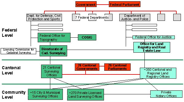
Figure 1: Organizations involved in the cadastral system.
B.2 Private Sector Involvement
The private sector carries out some 90% of the total work within cadastral surveying. The involvement of the private sector is a normal practice since the establishment of the cadastral surveying system in the early 1900's. This proved to be beneficial over the past decades and has further been confirmed over the last few years with the general trend of new public management demanding higher cost awareness and flexible market deregulations.
The private sector is commissioned with projects - through a tendering process - for data acquisition, upgrading, and updating. There is a long established and accepted system, through which the private sector is mandated with data updating and maintenance procedures. As such, the private surveyors are acting as public agents providing a decentralized service close to customers. With the availability of digital data, cantons and municipalities are introducing their own land information systems and private surveying offices quite often support such projects either by contract or by consulting.
With the many technological developments over the last few years, the involvement of the private sector proved to be very useful for the development of the whole cadastral system. Being forced - through the market situation - the private sector had to adapt processes and technologies, and picked up new possibilities, applications, and methods that helped to improve the system. The innovation potential of this private-public cooperation has benefited the whole cadastral surveying system.
B.3 Professional Organization or Association
Most of the cadastral surveyors are member in the "Swiss Association for Geomatics and Land Management" (Schweizer Verband für Geomatik und Landmanagement, geosuisse, www.geosuisse.ch), which has 658 members (Dec. 2017). geosuisse is a member association in FIG and is committed to the advancement of professional interests. The private sector cadastral surveyors are maintaining their own section within geosuisse: the "Swiss Cadastral Surveying Association" (Ingenieur-Geometer Schweiz, IGS, www.igs-ch.ch) representing the interests of the private sector.
The cantonal agencies for cadastral surveying are cooperating with each other and meet 3-4 times a year in the "Conference of the Cantonal Cadastral Services" (Konferenz der kantonalen Katasterdienste, CadastreSuisse, www.cadastresuisse.ch), where structural and strategic matters are being discussed in close cooperation with the Federal Directorate for Cadastral Surveying (V+D).
B.4 Licensing
With the introduction of the land registration system in 1910, the Confederation also introduced a regulation for the licensing of cadastral surveyors. Only licensed land surveyors are allowed to carry out cadastral surveying. The practical examinations are organized by the Commission for Cadastral Land Surveyors (Geometerkommission, in German, French, Italian only). The first examination has been held in 1913 and there are some 6-10 candidates on average that pass the licensing exams annually.
The licensed land surveyor can carry out cadastral surveying in any of the 26 cantons, but must register itself in the Federal Register of Cadastral Land Surveyors (in German, French, Italian only). Although they are mostly operating in the private sector, they are public agents, bound by regulations and contracts.
B.5 Education
In Switzerland, a distinction is made between different levels of education:
- Geomatician: a four-year apprenticeship;
- Bachelor and Masters of Science FH in Geomatics:
- Bachelor and Masters of Science (at one of the two Federal Institutes of Technology):
- ETH Zurich: Geomatic Engineering and Planning;
- EPF Lausanne: Laboratories of TOPO and GIS.
The number of students is stable, although at a low level. There are on-going initiatives in order to better spread the information about the profession and to attract more students.
C. Cadastral System
C.1 Purpose of Cadastral System
From 1912 until 1993, the cadastral system had purely a legal purpose and was mainly geared for securing land ownership rights. The cadastral surveying data have always widely been used as basis for utility mapping and many sorts of municipal planning and management purposes.
With the introduction of the fully digital format in 1993, the data of cadastral surveying are serving - next to land registration - also as basis for any land information systems.
The enactment of the Act on Geoinformation in 2008 then also provided the basis to add another 17 information layers documenting public-law restrictions; full coverage is expected for 2020.
C.2 Types of Cadastral System
There is only one comprehensive cadastral system, which by definition of land parcels covers the whole territory in a complete way. Every piece of land is a parcel with an assigned owner. Roads or public areas can be owned by public bodies, such as municipalities, cantons, or federal offices. Also legal bodies such as private companies or corporations can be owners of land parcels.
C.3 Cadastral Concept
The cadastral system is based on a folio principle, i.e. each "land parcel" on the ground is related to exactly one ownership title registered in the land registry. Every land parcel has a unique parcel identifier number, to which all parcel-relevant information is linked. Buildings are by definition integral parts of "land parcels" and by default cannot cross parcel boundaries. In the case of a building sitting on top of a parcel boundary, the boundary would need to be rectified accordingly or the two parcels would need to be merged. Land parcels can be sold only as complete entities. If only a part of a parcel is to be sold, it has to go through a subdivision process by first creating a new parcel, where the new boundary is delimited by a predefined cadastral survey process.
C.4 Content of Cadastral System
The cadastral system can be described consisting of the two main elements "land registration" and "cadastral surveying". The content of cadastral surveying is defined by a data model with 11 information layers (compare Figure 3). The original data model consisted of 8 information layers, but was amended with an additional 3 in 2004.
The content of the land registry is mainly the registration of properties, which can be:
- real estates (land parcels including buildings on them),
- servitudes and easements,
- mines, and
- condominiums.
D. Cadastral Mapping
D.1 Cadastral Map
The "digital" cadastral data model consists of 11 information layers as illustrated in Figure 3. By definition, the two layers "Land cover" and "Ownership" cover the whole territory in a complete way, i.e. without overlaps and without gaps, while other layers have different structural definitions. Buildings are part of the "land cover" layer. Each of the 11 information layers is object-oriented and defined by an entity-relationship diagram, which is at the same time the data model and the basis for the exchange of data between different systems and partners. The exchange of data is crucial in a federative and client-oriented cadastral surveying system. The data model is described with the system independent description language INTERLIS.
The accuracy of cadastral surveying and the degree of detail are prescribed in 5 different levels according to the economic value of the areas: city centers, settlement areas, intensively used agricultural areas, extensively used agriculture areas, and mountain areas.
Cadastral surveying data is based on a national control point system, organized in a hierarchy of 3 orders. The vast majority of geographic data in Switzerland are based on a specific geodetic reference framework (oblique Merkator projection), which has been adapted to modern GPS requirements (free of distortions) by the end of 2016.
D.2 Example of a Cadastral Map
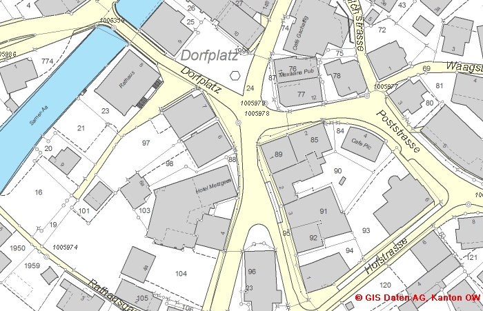
Figure 4: Example of a cadastral map extract.
D.3 Role of Cadastral Layer in SDI
The early stages of an SDI in Switzerland began in 1993 with the introduction of the digital format and the new data-modelling concept for cadastral surveying. The basic element of that concept was the data description language INTERLIS, with which spatial data can be defined, modelled, and exchanged without information loss and independent from any system restrictions. The data model for cadastral surveying is defined in the Federal Ordinance TVAV and legally binding for cadastral surveying in all cantons.
The data-modelling concept with INTERLIS has triggered the definition of more than 150 other spatial data domains by other SDI partners over the last 20 years, enabling the use of the same data exchange mechanisms as cadastral surveying. With the introduction of the INTERLIS concept, cadastral surveying can be regarded as the forerunner for the SDI development in Switzerland.
The cadastral data with its 11 information layers is only one among many data sets within the national geodata portal. But it is the most crucial data set, as with the land ownership and the other layers it provides the basis for any land administration and land management activities.
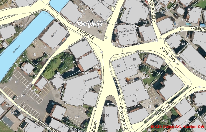
Figure 5: Example of cadastral map combined with orthophoto map.
E. Reform Issues
E.1 Cadastral Issues
Full coverage of digital cadastral surveying data: even though the legislation for the digital data format has been put in force in 1993, cadastral surveying is still in the process to finalize the transformation from paper-based data to digital data. Paper-based data are still in use in remote mountain areas with little economic and thus land market activities. The national administration is now pushing for a full digital coverage until 2020.
Federative management: the federal context, in which cadastral surveying is being operated in Switzerland has many advantages (subsidiarity principle), but also some limits. The biggest obstacles are felt to be the cantonal data copyright and fee setting right, effectively preventing a homogenous fee structure and policy for cadastral surveying data on a national level. The adoption of the Open Government Data (ODG) approach by the Federal level and by 11 cantons (Sep. 2018) so far may help to ease the situation.
E.2 Current Initiatives
Integration of "Public-law restrictions" and "servitudes": Another 17 information layers – documenting public-law restrictions – are being integrated into the cadastral system; full coverage is expected for 2020. Another initiative is looking at the need for the integration of "servitudes".
DM.xx: The data model DM.01 for cadastral surveying with its 11 information layers is being reviewed at the moment by a working group called "DM.flex". The main reason for the review is that DM.01 has been defined and structured mainly to replace directly the traditional paper-based cadastral map with all its traditional elements. Thus the underlying configuration is not fit-for-purpose for modern information systems and will therefore be upgraded to a more modern approach with a topic-related configuration.
3D, underground facilities: The recent suggestion of a fully 3D-Cadastre has not found the agreement by the land registry. Cadastral surveying, however, clearly feels the need for a 3D documentation of ownership, mainly for the increasing and potentially conflicting use of the underground. A project called "3D Cadastre" remains active.
F. References
- Cadastral Surveying at Federal Office of Topography swisstopo
- Federal Office for Land Registry and Real Estate Law in the Federal Office for Justice
- INTERLIS - The Geo Language
- Wikipedia - general description of Swiss cadastral system (in German)
- Wikipedia - general description of Swiss cadastral system (in French)
- Wikipedia - general description of Swiss cadastral system (in Italian)
Part 2: Cadastral Principles and Statistics
1. Cadastral Principles
1.1 Type of registration system |
|
title registration
deeds registration |
1.2 Legal requirement for registration of land ownership |
|
compulsory
optional |
1.4 Approach for establishment of cadastral records |
|
systematic
sporadic both, systematic and sporadic all properties already registered |
2. Cadastral Statistics
2.1 Population |
8,419,550 |
2.2a Population distribution: percentage of population living in urban areas |
75 |
2.2b Population distribution: percentage of population living in rural areas |
25 |
2.3 Number of land parcels |
4,013,200 |
--- Number of land parcels per 1 million population |
476,600 |
2.4 Number of registered strata titles/condominium units |
200,000 |
--- Number of strata titles/condominium units per 1 million population |
23,700 |
2.5 Legal status of land parcels in URBAN areas: |
|
percentage of parcels that are properly registered and surveyed |
100 |
percentage of parcels that are legally occupied, but not registered or surveyed |
0 |
percentage of parcels that are informally occupied without legal title |
0 |
2.6 Legal status of land parcels in RURAL areas: |
|
percentage of parcels that are properly registered and surveyed |
100 |
percentage of parcels that are legally occupied, but not registered or surveyed |
0 |
percentage of parcels that are informally occupied without legal title |
0 |
2.7 Number of active professional land surveyors |
354 |
2.8 Proportion of time that active professional land surveyors commit for cadastral matters (%) |
80 |
--- Approx. full-time equivalent of land surveyors committed to cadastral matters |
283 |
2.9 Number of active lawyers/solicitors |
700 |
2.10 Proportion of time that active lawyers/solicitors commit for cadastral matters (%) |
70 |
--- Approx. full-time equivalent of active lawyers/solicitors committed to cadastral matters |
489 |