Iran
 |
|
Contact person for provided information:
Dr. AHMAD TOISERKANI RAVARI
Head of The State Organisation for Registration of Deeds & Properties
No.3,Fayyazbakhsh St. Emamkhomeyni Sq. Tehran -Iran
toiserkani@ssaa.ir
Part 1: Country Report
A. Country Context
A.1 Geographical Context
Iran is the large country in Middle East, with a total area of 1,648,195 sq km, lying south of Armenia, Azerbaijan, Turkmenistan, and nourth of Qatar, U.A.E, Bahrein, Saudi-Arabia, Kuwait and west of Pakistan and Afghanistan and east of Iraq and Turkey. The Land Boundary is almost 5,261 km along above countries. The Coast Line is about 2440 km along Caspian Sea, Oman Sea and Persian Golf. According to the National Geographic Organization statistics the Total length of Iranian borderlines is 8731 km. The Iran-Iraq borderline is 1609, Iran-Turkey borderline is 486, Iran-Turkmenistan borderline is 767, Iran-Armenia borderline is 40, Coastline in north is 657, Iran-Afghanistan borderline is 945, Iran-Pakistan is 978, and Coastline in south is 2043 km.
At least 13 neighbours are connected to our border and for this reason Iran has very Important. The population is approximately 65.5 million, with a growth rate of about 1.5%. The largest Lake in the world is located in the North of Iran which is called Caspian Sea. The Capital is Tehran and The Climate is mostly arid and semi-arid; subtropical along the Caspian Sea. The Language is Persian (51%) and Persian dialects but there are some other ones such as: Kurdish(7%), Luri(2%), Balock(2%), Arabic(3%), Gilaki and Mazandarani(8%), Turkish(24%). The Religion is mostly Islam (99%) that 89% of the people is Shia and 10% of them is Sunni and 1% is Zoroastrian, Jewish, Christian and Bahai. The Currency is 1 Toman which is equal to 10 Iranian rials.
A.2 Historical Context
Ancient Iran, also known as Persia, historic region of southwestern Asia that is only roughly coterminous with modern Iran. The term Persia was used for centuries, chiefly in the West, to designate those regions where Persian language and culture predominated, but it more correctly refers to a region of southern Iran formerly known as Persis, alternatively as Pārs or Parsa, modern Fārs. Parsa was the name of an Indo-European nomadic people who migrated into the region about 1000 BC. The first mention of Parsa occurs in the annals of Shalmanesar II, an Assyrian king, in 844 BC c. During the rule of the Persian Achaemenian dynasty (559–330 BC), the ancient Greeks first encountered the inhabitants of Persis on the Iranian plateau, when the Achaemenids—natives of Persis—were expanding their political sphere. The Achaemenids were the dominant dynasty during Greek history until the time of Alexander the Great, and the use of the name Persia was gradually extended by the Greeks and other peoples to apply to the whole Iranian plateau. This tendency was reinforced with the rise of the Sāsānian dynasty, also native to Persis, whose culture dominated the Iranian plateau until the 7th century AD. The people of this area have traditionally referred to the region as Iran, “Land of the Aryans,” and in 1935 the government of Iran requested that the name Iran be used in lieu of Persia. The two terms, however, are often used interchangeably when referring to periods preceding the 20th century.
Recent archaeological studies indicate that as early as 10,000 BC, people lived on the southern shores of the Caspian, one of the few regions of the world which according to scientists escaped the Ice Age. They were probably the first men in the history of mankind to engage in agriculture and animal husbandry.
Iran has long played an important role in the region as an imperial power and later—because of its strategic position and abundant natural resources, especially petroleum—as a factor in colonial and superpower rivalries. The country’s roots as a distinctive culture and society date to the Achaemenian period, which began in 550 BC. From that time the region that is now Iran has been influenced by waves of indigenous and foreign conquerors and immigrants. The following dynasties that ensued were called the Parthians, the Sassanian, the Arabs (such as Omayyads, Abbasids), Ghazna, the Seljuk Turks, the Kharazmshahi, the Safavid, the Zand, the Qajar, the Pahlavi, and at last Islamic Republic.
In 1979 the Iranian revolution took place and the leader of the revolution and founder of the Islamic Republic, Ayatollah Ruhollah Khomeini, became Iran's supreme leader until his death in 1989.
Since 1980, which the first Iranian presidential election was held, Ali Khamenei, Akbar Hashemi Rafsanjani, Mohammad Khatami and Mahmoud Ahmadinejad were each elected president for two terms. Hassan Rouhani is the current president, being elected in June 2013 presidential election
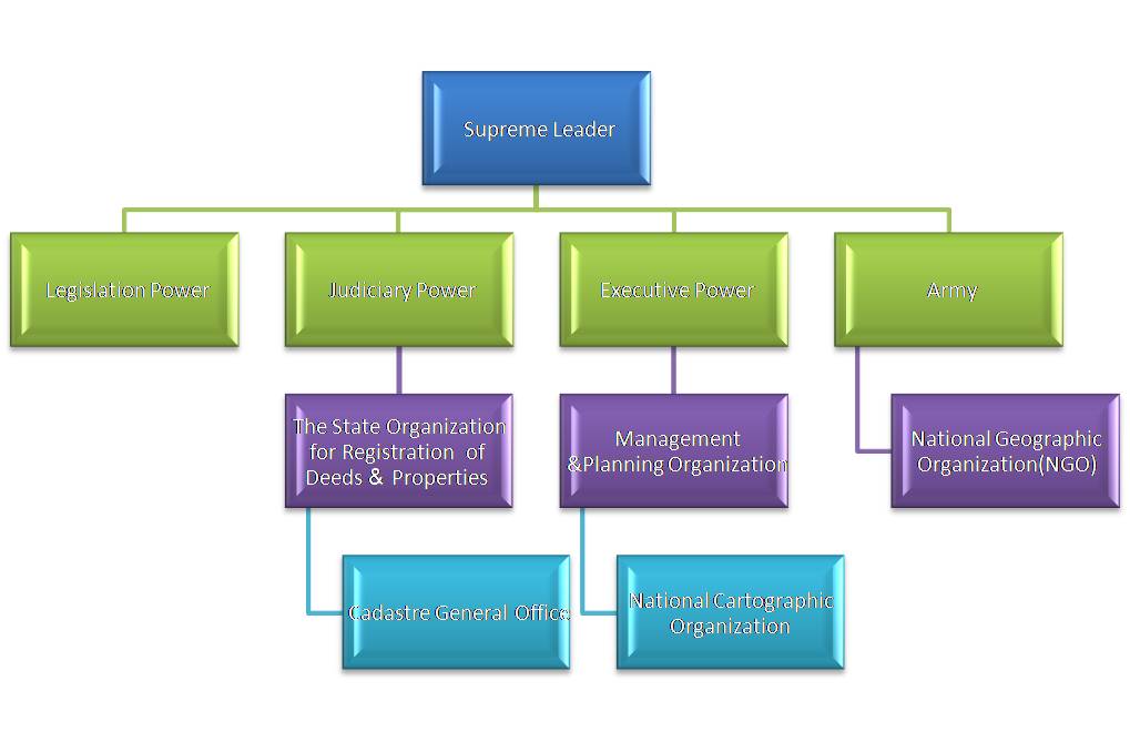
A.3 Current Political and Administrative Structures
The Judiciary in the Constitution
The judiciary is of vital importance in the context of safeguarding the rights of the people in accordance with the line followed by the Islamic movement, and the prevention of deviations within the Islamic nation. Provision has therefore been made for the creation of a judicial system based on Islamic justice and operated by just judges with meticulous knowledge of the Islamic laws. This system, because of its essentially sensitive nature and the need for full ideological conformity, must be free from every kind of unhealthy relation and connection (this is in accordance with the Koranic verse "When you judge among the people, judge with justice"
A.4 Historical Outline of Cadastral System
The law for deeds & properties registration was passed in April 1911 by the second Iranian Parliament.
The 126-article law for deeds & properties registration was passed in March 1923 according to which Iranian Deeds & Properties Registration Organization (IDPRO) was founded to stabilize people's proprietary rights and registration of documents made by them. Official name of organization is” the state organization for registration of deeds and properties” which consisting of Cadastre and Land Registry and also deeds registration, as we comprise in one single organization. With the establishment of IDPRO, it was expected that people were encouraged to investment because of judiciary & legal stability, and the government received taxes for transactions.
In addition to its principal reason of existence, IDPRO is a source of income for the government and gets much more than what it needs for its costs. The surplus is transferred to the treasury.
NOTARY OFFICES
All contract preparation and the decision on legal acceptance is carried out by the Notary Public. The Notary public then presents the Deeds to the Land Registry Office for registration. The Land Registry only receives a summary of the Deed; the original is given to the applicant.
The public notary guarantees the content of the Deed and the Land Registrar is also responsible for the content on behalf of the administration in law
CADASTRE PROJECT
Iran Cadastre Project for Urban Area was passed in 1989 by Islamic Iranian Parliament and officially started working under Iran’s Deeds and Properties Registration Organization. On the basis of this project, a technical committee was established in 1990 to study and research. This committee prepared a plan for implementing the project and began executive studies on the main objectives, financial and also the required applications and instruments. It was assigned the project to be implemented within twenty years. Now this project has progressed and prepared a lot of digital cadastral maps and its attributes in an integrated Data Base
Establishing an exact, simple, rapid, certain and changeable system during the time for managing the affairs related to properties and buildings in the country.
Quantitative objects:
1. Legal Delimitation for ownership of different buildings (1,200,000 hectares urban cadastre) and fields belonging to real and government bodies and of endowed fields.
2. Reviewing the information and maps during the lifetime of cadastre project and finally changing the existing system to modern registration system (cadastre).
Qualitative objects:
1. Providing simple and certain relationship for deeds issuing amending immediately and accurately.
2. Creating certainty and speed in properties transactions.
3. Widespread decreasing of trespassing in properties and the relevant claims in the law courts.
4. Access to the needed financial cadastral information or, eventually, providing of such information.
5. Utilizing the technical cadastral documents such as maps, aerial photos, and other information for researching, developing and preparing the urban development programs.
6. Supporting the right of government in all stages of property transformations on basis of the relevant deeds.
7. Supporting the income of the government directly or indirectly.
8. Procuring a continuous income by selling the maps and cadastral data to the clients, private and public sectors.
9. Access to the necessary means for housing policy, land, property and division of population and development of cultural, social, economical and agricultural planning.
10. Providing useful technical occupation in different fields of surveying, computer and legal registration.
The Comprehensive State Cadastre Act
The above Act, constituted of twenty article and eleven notes, was legislated during the public session of Sunday, February one, two thousand fifteen, and was approved by the Guardian Council on February 18, 2015.
Article 3- The organization is obligated to carry out the cadastre within five years from the date of the act's entry to force, in a manner that the position and the limits of all properties and lands within the geographical borders of the country – whether governmental or non-governmental – and also the positions and the limits of all mountains, pastures, forests, seas, lakes, lagoons, constructed coastal lands, functioning and obsolete waterways, and the islands of the country are defined and registered, and the utilization of charts and other descriptive and registry data of all properties and lands of the country in form of charts and cadastral ownership documents becomes possible in a way that no point in the country is uncharted and lacking cadastral ownership documents.
- Note- All agencies are obligated to cooperate with the organization to carry out the cadastre [operation].
B. Institutional Framework
B.1 Government Organizations
The Cadastral Office centralized all cadastral maps in Iran at the Capital (Tehran). But during few years ago the all provinces (31provinces ) in Iran established their divisions within the Province. They collected the data for provincial cadastre andthey are going to manipulating data and solving the problems within the province.
B.2 Private Sector Involvement
Most cadastral surveys are undertaken by the private sector. Qualification of a license or registration for surveying firms is required to perform cadastral surveys, and accredit by Management & Planning Organization, same as the other surveys such as engineering surveys. Management of the geodetic network and the other fundamental activities remains primarily a government responsibility, however updating and upgrading is not often the responsibilty of the private sectors.
B.3 Professional Organization or Association
There is a main organization for mapping and geomatics purposes which is called National Cartographic Centre (NCC) comprising of around 1000 members. There is a Division in all provinces. NCC is represented in the International Federation of Surveyors (FIG) and also represented in the Permanent Committee on GIS Infrastructure for Asia & the Pacific (PCGIAP). Iran made some activities in International Society for Photogrammetry and Remote Sensing (ISPRS) such as presenting the papers or workshops. Iran also has representative in the ISO/TC211 Committee (as observer) to standardize the whole activities in the field of Geomatics with international viewpoint. Other than above associations some other societies or cants exist in Iran such as: Iranian Society of Surveyors, Iranian Society of Remote Sensing and GIS and Iranian Society of Surveying and Geomatics Engineering.
B.4 Licensing
Management and Planning Organization identify guidelines for licensing and registration of (cadastral) land surveyors. A firm applying for registration must be issued with a certificate of competency in cadastral surveying which is issued by Management and Planning Organization (MPO) and in addition must pass some further professional examinations and practical exercises supervised by the Board of Surveying engineers. An expert who has the Geomatic background could take part in the examination to get the certification from courthouse (for the period of time) to solve the disputes between the claims if the court wants to know which one has a right. This certification must be renewed after a period of time.
B.5 Education
The Cadastral Office has sent a lot of students (around 3,000) to the universities such as: Tehran, Khajenasir-addin, Azad, and so on to get the degrees (BSc & Msc in Geomatics, Surveying Mapping, Photogrammetry, Cartography ...). About 10% of them studying at these universities are women.
C. Cadastral System
C.1 Purpose of Cadastral System
The First Cadastre Project's objective is to develop a real estate registration program which will provide:
(a) Property owners with security of ownership rights;
(b) commercial banks with the confidence necessary to give secured credit against real estate;
(c) the real estate market with information on ownership and location of property as needed for the market to function effectively;
(d) Government agencies and institutions with basic information for urban planning and land management;
(e) The real estate market with information or property values; and
(f) The private sector with opportunities to develop in areas related to real estate registration.
In Iran the objective of the cadastral project is the creation of a Legal Cadastre system at this time and consequently multipurpose cadastral system in the future.
C.2 Types of Cadastral System
Historically to distinguishing the ownership of properties a conventional land registration system developed for the semi accurate mapping, surveying, management and administration of public and private lands. Through computerization of the abstract of Deeds these two mapping systems must be integrated to facilitate wider land management and environmental planning. Today the aim is to distribute the activities of cadastral mapping through the provinces with the responsibility of maintaining an updating within provincial cadastral offices. The Economic Ministry also supports fiscal cadastre and fulfil the all taxation activities inside the country. There is urgent necessity to integrate these three agencies (Ministry & Organization) and coordinates the activities.
C.3 Cadastral Concept
Cadastral systems in Iran are operated by the 431 regitery offices in 31 province and operate in such a way that land parcels are surveyed in the field while the corresponding land ownership titles are recorded in the Land Registry. The Land Registry uniquely identifies each parcel corresponding to the title if the property has formal deed. The relationship between these two main units is usually a 1:1-relationship, i.e. each land parcel is usually related to one land ownership entry in the land registry.
The taxation and legal aspects are doing in parallel ways. Nowadays in Iran we are trying to have one street address for each property within the cities and each property usually has one or more houses or apartments. On the other hand the Iranians are going to have Civic codes as well (which is called Melli Code in Iran). In most cases, however, a property consists of one parcel only. While the title registration is of interest to the land registry, the most cases (around 80% or more) to transfer the land or property is, issuing the advocacy letter (which is called Bonchagh in Iran) and is very efficiently doing. Land and Buildings are part of the property records with records maintained by many local councils, especially in rural areas, as well.
According to the law, if somebody doesn’t have any formal evidence to prove his ownership, he could come to land registration and apply one (The Laws 147 & 148 in Land Registry). The cadastral office will survey his property and give him the deed within certain time if there is no adversely claim comes up on that time.
C.4 Content of Cadastral System
Iranian Cadastral system typically comprises the following components:
- Database Component – the land register identifies real property parcels, which includes all land parcels and identifies owners’ rights.
- Spatial Component - Cadastral maps show all land parcels graphically corresponding to the registered title with plan numbers and unique identifiers. These are all now digitised. Cadastral maps consist of fixed and general boundaries.
- Fixed boundaries are those with legally surveyed measurements used to precisely identify most parcel boundaries determined by cadastral surveys such as subdivision etc.
- General boundaries (graphical) are not survey accurate or are not distinguish at photos and are based on natural or man-made physical features, such as walls and buildings as found on Cluster or Strata Titles.
- Additional legal, valuation, local government, utilities and planning activities are involved in land administration, and are heavily reliant on the fundamentals of the cadastral system. In particular local government rates, land tax and stamp duty (as a result of land transfer) on land parcels is a major revenue raiser for the economy.
- Vaghf Lands Management have management and administrative responsibility for some public state owned lands
D. Cadastral Mapping
D.1 Cadastral Map
The map in scale of 1:500, using photogrammetric outputs of the cadastral system is the standard digital base and field surveying methods. This procedure is the same procedure which is used to prepare the 1:25000 map scale for whole country. The total number of digital maps covering urban areas prepared in 1:500 scale figures to around100,000 sheets. These sheets should cover at least 1,200,000 hectars in urban areas. Since 1989 till 1996 the cadastral maps includes around 71 features with 270 fields in databases. But after that time they decided to have just 4 features on the maps with few fields in databases only for legal purposes.
The Tehran GIS office within the Municipality of Tehran also prepare the 1:2000 map scale for own purposes. It should be integrated with cadastral activities in Tehran.
D.2 Example of a Cadastral Map
Below is one example of the different digital cadastral maps vary based on applications e.g. the Nort of Tehran map at scale 1:500 (especial case, Fig. 1)
D.3 Role of Cadastral Layer in SDI
Iran currently does not have a formal NSDI, but the subject has been addressed in Iran’s National Plan for Map and Spatial Data production (currently reviewed by the HCSM, High Council of Surveying and Mapping). The HCSM coordinates all geomatics and geodetics activities within the country as a whole and conduct the SDI in future. The role of cadastral data in establishment of NSDI is quite significant so that, Iran’s Deeds and Properties Registration Organization by it's project for cadastre performance, prepared a powerful integrated data base in country for more than 96 percent of Urban area and for legal attributes of more than 32million registered parcels of public and private owners, which are maintaining in digital database. The Cadastral office has right to have a nominate in HCSM and consequently, has a main role in establishing SDI in Iran.
E. Reform Issues
E.1 Cadastral Issues
-
1. Boundary disputes: Nowadays there is a lot of Disputes Settlement in Iran that needs to make conformity between the accurate maps which are producing by Cadastral Office and Conventional maps which are using inside the Land Registry Organization.
2. Expropriation and Compensation: During civil activities especially in cities, some lands and parcels are taken by the Government to promote the facilities there and compensate somewhere else.
3. Reform on the laws and rules: Sometimes the rules and laws are doing the opposite way of cadastral office interests and needs to be reformed as well. The old rules conflict to the modern technology and its strategies.
4. Protection of Property Rights: the government of Iran recognizes intellectual property rights. Iran is a member of the Paris Convention for Protection of Industrial Property. Iran has legislated its own trademark and patent laws to protect both national and expatriate property.
5. Private Ownership Rights: In general, ownership of private property is respected. Foreigner individuals or corporate entities who wish to own immobile property are required to ask permission from the government of Iran.
6. The amount of foreign direct investment is limited to 49 percent of a joint venture and the partnership must be made with Iranian nationals.
7. Moving from Deed to Title Registration: Historically Deed Registration is very efficient and public today. But Government has some encouragement tools to invite people to have the title Registration as well.
8. Facilitating the use of legal land parcels and legal property objects to better manage all rights, restrictions and responsibilities relating to land;
9. - Developing more holistic data models to integrate separated datasets.
10. - Completing and updating national cadastral maps of legal parcels, properties and legal objects, as the main part of the NSDI
E.2 Current Initiatives
- Automation of Abstracts of Deeds: In some Land registration offices especially in Tehran, the abstracts of deeds have been recorded in the computer and expected to have full digital abstraction within two next years.
- Make a new Cooperation between Cadastre and the other mapping agencies: The National Cartographic Centre and Cadastral office as well as National Geographic Organization have intention to be coordinated through HCSM and also have recently some directly linkage between them.
- Make the networks within the provinces to access the cadastral data: Within state there is strong need to change or send the data and make some legal queries as well.
RECENT ACHIEVEMENTS
Project of Land Registry Archive Information System
-
The objectives of the project are:
- • To scan the existing archive documents, by using the latest technology,
- • To transcribe them and transform them into a digital media,
- • By installing the archive automation software and establishing the framework, toEnsure that the authorized people can easily access archive information and Documents within the required security framework.
- • Now majority of gathering data are in digital format, and stored in easy accessible databases, it became more easy to make special selections and combinations of data, also with those of other data providers, which creates opportunities to deliver reliable products, which obviously meet market demands and encourage economic activities and growth.
- • Maintenance of cadastral data and land registry data is decentralized to the land registry and cadastre offices (more than 430 of each)
- • The land register and cadastral data are linked by property(registered parcel) identifier.
- 100% of the land registry records (registry book) are available in computerized extract form
F. References
- www.sci.or.ir - IRAN Statistical Digest 1380 (Statistical Centre of Iran)
- www.countrywatch.com
-
www.ssaa. ir
- Report of the audit mission of Cadastral office.
- Ministry of Interior of Iran
- Ministry of Economic affairs and Finance
- Ministry of Foreign Affairs of Iran
Part 2: Cadastral Principles and Statistics
1. Cadastral Principles
1.1 Type of registration system |
|
title registration
deeds registration |
1.2 Legal requirement for registration of land ownership |
|
compulsory
optional |
1.4 Approach for establishment of cadastral records |
|
systematic
sporadic both, systematic and sporadic all properties already registered |
2. Cadastral Statistics
2.1 Population |
75,597,500 |
2.2a Population distribution: percentage of population living in urban areas |
71 |
2.2b Population distribution: percentage of population living in rural areas |
29 |
2.3 Number of land parcels |
34,000,000 |
--- Number of land parcels per 1 million population |
449,700 |
2.4 Number of registered strata titles/condominium units |
27,000,000 |
--- Number of strata titles/condominium units per 1 million population |
357,100 |
2.5 Legal status of land parcels in URBAN areas: |
|
percentage of parcels that are properly registered and surveyed |
36 |
percentage of parcels that are legally occupied, but not registered or surveyed |
62 |
percentage of parcels that are informally occupied without legal title |
2 |
2.6 Legal status of land parcels in RURAL areas: |
|
percentage of parcels that are properly registered and surveyed |
25 |
percentage of parcels that are legally occupied, but not registered or surveyed |
74 |
percentage of parcels that are informally occupied without legal title |
1 |
2.7 Number of active professional land surveyors |
14,000 |
2.8 Proportion of time that active professional land surveyors commit for cadastral matters (%) |
60 |
--- Approx. full-time equivalent of land surveyors committed to cadastral matters |
8,400 |
2.9 Number of active lawyers/solicitors |
40,000 |
2.10 Proportion of time that active lawyers/solicitors commit for cadastral matters (%) |
30 |
--- Approx. full-time equivalent of active lawyers/solicitors committed to cadastral matters |
12,000 |